
Thursday, 04 June, 2026г.


Где искать: по сайтам Запорожской области, статьи, видео ролики
пример: покупка автомобиля в Запорожье
VPS Sample 2
 У вашего броузера проблема в совместимости с HTML5
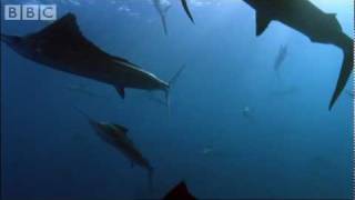
A time-series animation of VR2W Positioning System (VPS) results using Google Earth. Each fish in the system is shown using a different coloured dot, and Google Earth was configured to show all fish positions over a sliding window of time. This allows you to see the fish tracks.
Principal investigators: Jason McLellan / Matt Howell
Washington Department of Fish and Wildlife
Funding provided by the Washington Department of Ecology and US Geologic Survey
Похожие видео
Мой аккаунт