

Thursday, 06 August, 2026г.
















Где искать: по сайтам Запорожской области, статьи, видео ролики
пример: покупка автомобиля в Запорожье
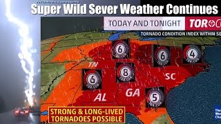
East Coast Frankenstein Storm Philippe to Cause MAJOR Wind & Flood Damage
 У вашего броузера проблема в совместимости с HTML5
North East coast stay aware & be alert. This storm is deadly.
We're looking at sustained windspeeds from 50-70 mph & 5-7 inches of rain along a 300 mile area.
play this one smart, y'all.
https://www.paypal.me/THORnews
Stay cool.
God bless everyone,
T
https://www.paypal.me/THORnews
@newTHOR on twitter
article on storm
https://www.wunderground.com/cat6/cuba-south-florida-bahamas-line-drenching-93l-organizes
Cuba, South Florida, Bahamas In Line for Drenching as 93L Organizes
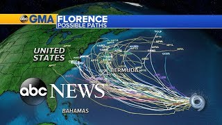
Hurricane Hunters were en route Friday afternoon to the Northwest Caribbean, where a long-simmering tropical disturbance showed increasing signs of organization. Models support the idea that the disturbance, called Invest 93L, could become a tropical depression or tropical storm as it moves across Cuba, near South Florida, and through the Bahamas this weekend. In addition, moisture from the vicinity of 93L will get swept northward, helping to juice a powerful midlatitude storm expected to slam parts of the U.S. Northeast from Sunday into Monday. [Update: At 5 pm EDT Friday, the National Hurricane Center upgraded 93L to Potential Tropical Cyclone 18. The PTC designation, introduced earlier this year, applies to systems that are not yet full-fledged tropical cyclones but that could intensify and bring tropical-storm conditions to land areas within the next 48 hours. Tropical storm warnings have been issued for parts of Cuba and The Bahamas. Although the Hurricane Hunters found winds of tropical storm strength within PTC 18, there was not yet a well-defined center of circulation.]
At 2 pm EDT Friday, the center of 93L was located just off the eastern tip of Honduras. As it’s drifted north over the last 24 hours, 93L has moved into a frontal zone stretching from the Northwest Caribbean into the Northwest Atlantic. Reinforcement from converging low-level winds along this front appears to have given a boost to 93L, with an expanding area of strong showers and thunderstorms (convection) beginning to consolidate.
Intensity forecast for 93L
Wind shear around 93L is on the decrease: the 12Z Friday run of the SHIPS model predicts that shear will be less than 10 knots from midday Friday until Saturday evening. The mid-level atmosphere is quite moist (around 70%) and sea-surface temperatures are very warm (around 30°C or 86°F). There is also a pool of high oceanic heat content centered in the Northwest Caribbean, which would lend further support to any development. Together, the above factors will give 93L a brief window of very favorable conditions for development before shear begins to rapidly increase on Saturday night. This may be enough time for a tropical storm to form, although the increasing shear, the limited time frame, and the expected interaction with Cuba make it very unlikely 93L would reach hurricane strength.
The GFS and European model ensemble forecasts from 00Z Friday gave 93L a 50-70% chance of becoming a depression and a 25-30% chance of intensifying into a named storm. None of the 70 ensemble members generated a hurricane. In its 2 pm EDT tropical weather outlook, NHC gave 80% odds that 93L would develop into at least a tropical depression by midday Sunday. The next name on the Atlantic list is Philippe.
Track forecast and potential impacts from 93L
The track forecast for 93L is straightforward, thanks to a strong upper-level trough moving into the eastern U.S. that will capture 93L over the weekend. 93L should continue to drift north through Friday night, then accelerate northeastward from Saturday into Sunday ahead of the trough. It now appears less likely that 93L be interacting interact directly with the intense surface low that's predicted to form off the East Coast and race northward Sunday in association with the upper trough. Instead, 93L will more likely merge with the strong front that will sweep ahead of the trough from the Southeast U.S. into the Northwest Atlantic late Sunday.
Heavy rain is the main threat from 93L. Track models are in close agreement that 93L will move across central Cuba late Saturday, most likely as a weak tropical storm, then accelerate across the Bahamas early Sunday. The increasing motion will cut back on potential rainfall totals, but a swath of 2 – 6”, with locally higher amounts, can be expected across the Cayman Islands, central Cuba, and the Northwest Bahamas, along with gale-force winds. Across South Florida, widespread 1 – 4” totals can be expected, in part due to interactions with the approaching upper-level trough.
Moisture from 93L will be funneled across the eastern U.S. in an atmospheric river on Saturday and Sunday, ahead of the approaching upper trough and cold front. Several north-south belts of heavy rain can be expected, with “training” cells moving from south to north along the corridors as they slowly translate east. One belt of heavy rain may produce 1 – 3”
Теги:
Earth Planet Sun Moon Solar NASA Science Weather Severe Storm Hurricane Tropical Rain Flood Surge Wind Texas Coast Houston Austin San Antonio Jet Stream Landfall What Where When Atmosphere Tornado DFW Rainfall Flooding Warning Cyclone stall radar new news video forecast prediction path track river record level lake bay High Low Pressure Atlantic Pacific Brooklyn Bronx Queens Staten Island NYC Jersey York Philadelphia Nova Scotia Canada
Похожие видео


Мой аккаунт