
Wednesday, 01 July, 2026г.


Где искать: по сайтам Запорожской области, статьи, видео ролики
пример: покупка автомобиля в Запорожье
Weird Weather Watch - The FUTURE is Stormy AF RN. - RainTrain problems
 У вашего броузера проблема в совместимости с HTML5
It's true.
God bless everyone,
T
https://www.paypal.me/THORnews
https://www.facebook.com/thornewsgo
@newTHOR on twitter
articles on the strange weather
https://www.wunderground.com/cat6/strange-days-ex-hurricane-ophelia-batters-ireland-under-orange-skies
Strange Days: Ex-Hurricane Ophelia Batters Ireland Under Orange Skies
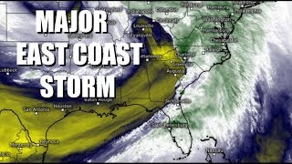
Ex-Hurricane Ophelia hit Ireland hard with full hurricane-like fury on Monday, bringing powerful winds that caused widespread damage and power outages. At least two deaths have been reported from trees falling on cars, and The Irish Times said at least 360,000 ESB Networks customers lost power in Ireland because of the storm. Ophelia’s center crossed the southwest coast of Ireland near 11:30 UTC Monday (12:30 pm local time), just 12 hours after the National Hurricane Center stopped issuing advisories on the Category 1 hurricane. NHC’s last advisory at 11 pm EDT Sunday gave top sustained winds of 85 mph to the storm, and ex-Hurricane Ophelia weakened only slightly before making landfall on Monday morning in Ireland. The storm took only about four hours to cross Ireland, and emerged from the north coast at approximately 15:30 UTC (11:30 am EDT) Monday.
Wind and storm surge observations
Ophelia brought winds typical of what we see from a landfalling Category 1 hurricane. Sustained winds of 50 mph were recorded at Cork at 10:30 - 11:30 am local time, and 54 mph at Shannon at 12:30 pm local time. (Note that sustained 10-minute winds are different from the 1-minute averaging time used by the National Hurricane Center and at U.S. airports to define sustained winds; 10-minute average winds need to be adjusted upwards by a correction factor ranging from 7% to 12% to get 1-minute average winds.) Some peak wind gusts recorded on Monday:
Fastnet Island, Ireland: 119 mph
Roches Point, Ireland: 97 mph
Waterford, Ireland: 85 mph
Cork, Ireland: 78 mph
Shannon, Ireland: 76 mph
St. Mary's Island, United Kingdom: 70 mph
Dublin, Ireland: 64 mph
Pembry, United Kingdom: 60 mph
Ophelia brought a storm surge that breached coastal defenses and flooded roads in Salthill on the western coast of Ireland'
A surreal day in Ireland
The surreal experience of a hurricane-like storm in Ireland was made even more strange by being preceded by an eerie sunrise that brought a hazy, orange sky across much of Ireland and Britain. The orange light was filtering through a thick layer of Saharan dust that had been transported to the north by the trough of low pressure that steered Ophelia northwards. Adding to the haze was smoke from wildfires in Portugal and Spain that killed at least 32 people over the weekend.
Europe may see an increase in strong ex-hurricanes in the future
Ophelia’s ascension to Category 3 status and subsequent impact on Ireland just 12 hours after becoming an ex-hurricane was made possible, in large part, by unusually warm ocean temperatures that were 1 – 2°C (1.8 – 3.6°F) above average. As the planet continues to warm due to the effects of human-caused global warming, we should expect to see more hurricanes maintaining their strength far to the north, allowing them to draw very close to Europe. According to a 2014 study led by University of Wisconsin hurricane scientist Jim Kossin, "The poleward migration of the location of tropical cyclone maximum intensity", there has already been a “pronounced poleward migration in the average latitude at which tropical cyclones have achieved their lifetime-maximum intensity over the past 30 years. The poleward trends are evident in the global historical data in both the Northern and the Southern hemispheres, with rates of 53 and 62 kilometres per decade, respectively.” The scientists hypothesized that this poleward shift could be linked to the expansion of tropics poleward that has long been predicted as a likely consequence of human-caused global warming. They noted that so far, though, the poleward trend observed in the Atlantic tropical cyclone database has been small.
Ophelia was an “off the charts” storm
One other way we know that Ophelia was an extremely unusual storm is that is broke some of the graphical displays we use to view the forecast. The National Hurricane Center graphical forecasts of the storm’s track had to be truncated east of 0° longitude (the Greenwich Prime Meridian), since they never planned for the possibility that an Atlantic hurricane or its identifiable remnants could make it so far to the northeast.
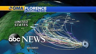
92L will affect Bermuda Monday night through Tuesday
A broad area of low pressure was located ab
Теги:
Earth Planet Sun Moon Solar NASA Science Weather Severe Storm Hurricane Tropical Rain Flood Surge Wind Texas Coast Houston Austin Landfall What Where When Atmosphere Tornado DFW Rainfall Warning Cyclone stall radar new news video forecast prediction path track river record level lake bay Ireland Raintrain Train High Low Pressure CME Stellar Star Neutron Gravity Gravitational Waves Wave England Pole Shift Magnetic Shield Magnetosphere Norway France Paris Climate 92L China Asia Japan
Похожие видео
Мой аккаунт