Где искать: по сайтам Запорожской области, статьи, видео ролики
пример: покупка автомобиля в Запорожье
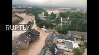
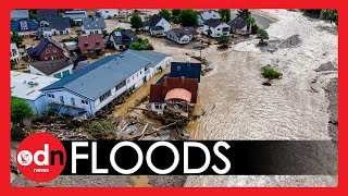
Germany: Satellite images capture extent of damage caused by floods *STILLS*
 У вашего броузера проблема в совместимости с HTML5
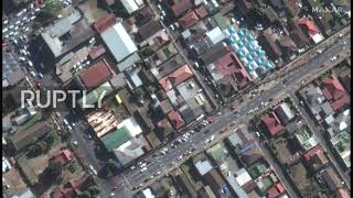
Mandatory credit: “Satellite image ©2020 Maxar Technologies” / · Print/web: Media may publish use these images with cutline photo credit “Satellite image ©2021 Maxar Technologies.” The watermark may not be removed/cropped.· Broadcast/video: Images used in video segments must have “Maxar” text applied to the image and visible for the duration that the images are on screen.· Social media: Images posted on social media must be credited on Twitter “[camera emoji]: @Maxar” or “image: @Maxar” in each post. Or via Instagram “[camera emoji}: @MaxarTechnologies” or “image@MaxarTechnologies” in each post.
Satellite imagery collected on Sunday shows the the aftermath of the recent floods along the Ahr River in western Germany.
Extensive damage can be observed in multiple towns along the river, with bridges washed away, buildings and homes destroyed and mud and debris covering streets.
The death toll in Germany and Belgium rose to 190, with dozens still reported missing. At least 160 are said to have died in Germany, where the floods are the country’s worst natural disaster in over half a century.
#Germany #Floods #Ahr #GermanyFloods
Video ID: 20210719-003
Video on Demand: https://ruptly.tv/videos/20210719-003
Contact: [email protected]
Twitter: http://twitter.com/Ruptly
Facebook: http://www.facebook.com/Ruptly